


RIF-05-22-1 DU 1.05.2022

bene_dictus77
User
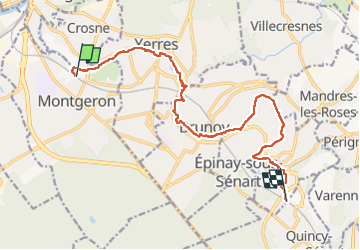

Length
13.6 km

Max alt
72 m

Uphill gradient
113 m
Km-Effort
15 km

Min alt
31 m

Downhill gradient
78 m
Boucle
No
Creation date :
2022-05-01 10:08:45.897
Updated on :
2022-05-01 15:09:04.024
4h19
Difficulty : Very easy

FREE GPS app for hiking
 SityTrail
IGN / Geographical institutes
SityTrail Plus
The world is yours!
About
Trail Walking of 13.6 km to be discovered at Ile-de-France, Essonne, Montgeron. This trail is proposed by bene_dictus77.
Description
de Montgeron à Boussy St Antoine
Positioning
Country:
France
Region :
Ile-de-France
Department/Province :
Essonne
Municipality :
Montgeron
Location:
Unknown
Start:(Dec)
Start:(UTM)
460316 ; 5395285 (31U) N.
Comments