


Saint-Laurent-en-Gâtines - Circuit jaune avec variante le Sentier - 18.7km 120m 4h30 - 2022 05 01

Orcal37
User GUIDE
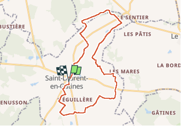

Length
18.7 km

Max alt
169 m

Uphill gradient
118 m
Km-Effort
20 km

Min alt
142 m

Downhill gradient
118 m
Boucle
Yes
Creation date :
2022-05-01 09:46:09.431
Updated on :
2022-05-01 18:42:49.502
4h30
Difficulty : Easy

FREE GPS app for hiking
 SityTrail
IGN / Geographical institutes
SityTrail Plus
The world is yours!
About
Trail Walking of 18.7 km to be discovered at Centre-Loire Valley, Indre-et-Loire, Saint-Laurent-en-Gâtines. This trail is proposed by Orcal37.
Description
Saint-Laurent-en-Gâtines - Circuit jaune avec variante le Sentier - 18.7km 120m 4h30 - 2022 05 01
Photos


Positioning
Country:
France
Region :
Centre-Loire Valley
Department/Province :
Indre-et-Loire
Municipality :
Saint-Laurent-en-Gâtines
Location:
Unknown
Start:(Dec)
Start:(UTM)
332922 ; 5272678 (31T) N.
Comments