


Vélo route Pont Julien - Céreste

Pascal84
User

Length
100 km

Max alt
491 m

Uphill gradient
1073 m
Km-Effort
115 km

Min alt
53 m

Downhill gradient
1164 m
Boucle
No
Creation date :
2022-05-01 09:36:57.407
Updated on :
2022-05-01 16:47:49.555
5h42
Difficulty : Very difficult

FREE GPS app for hiking
 SityTrail
IGN / Geographical institutes
SityTrail Plus
The world is yours!
About
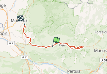
Trail Road bike of 100 km to be discovered at Provence-Alpes-Côte d'Azur, Vaucluse, Bonnieux. This trail is proposed by Pascal84.
Positioning
Country:
France
Region :
Provence-Alpes-Côte d'Azur
Department/Province :
Vaucluse
Municipality :
Bonnieux
Location:
Unknown
Start:(Dec)
Start:(UTM)
685365 ; 4859117 (31T) N.
Comments