


st Vincent de cramés il

doboul
User
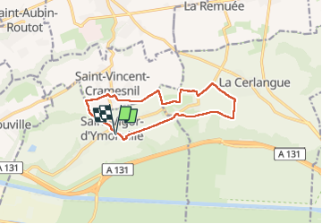

Length
11.1 km

Max alt
130 m

Uphill gradient
75 m
Km-Effort
12.1 km

Min alt
98 m

Downhill gradient
75 m
Boucle
Yes
Creation date :
2022-05-02 07:08:31.744
Updated on :
2022-05-02 09:54:58.313
2h44
Difficulty : Difficult

FREE GPS app for hiking
 SityTrail
IGN / Geographical institutes
SityTrail Plus
The world is yours!
About
Trail Walking of 11.1 km to be discovered at Normandy, Seine-Maritime, Saint-Vigor-d'Ymonville. This trail is proposed by doboul.
Description
Rando jm
Positioning
Country:
France
Region :
Normandy
Department/Province :
Seine-Maritime
Municipality :
Saint-Vigor-d'Ymonville
Location:
Unknown
Start:(Dec)
Start:(UTM)
308936 ; 5485741 (31U) N.
Comments