


Saint Romain de Colbosc

DDLEDANDY
User
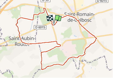

Length
11.8 km

Max alt
127 m

Uphill gradient
122 m
Km-Effort
13.5 km

Min alt
68 m

Downhill gradient
122 m
Boucle
Yes
Creation date :
2022-05-03 06:59:04.783
Updated on :
2022-05-03 09:48:55.993
2h48
Difficulty : Medium

FREE GPS app for hiking
 SityTrail
IGN / Geographical institutes
SityTrail Plus
The world is yours!
About
Trail Nordic walking of 11.8 km to be discovered at Normandy, Seine-Maritime, Saint-Romain-de-Colbosc. This trail is proposed by DDLEDANDY.
Description
On y longe un peu trop des routes fréquentées. Peu intéressant.
Positioning
Country:
France
Region :
Normandy
Department/Province :
Seine-Maritime
Municipality :
Saint-Romain-de-Colbosc
Location:
Unknown
Start:(Dec)
Start:(UTM)
307796 ; 5489588 (31U) N.
Comments