


motarone tracé

Yeti38
User
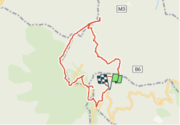

Length
9.3 km

Max alt
1493 m

Uphill gradient
476 m
Km-Effort
15.6 km

Min alt
1173 m

Downhill gradient
471 m
Boucle
Yes
Creation date :
2022-05-03 08:07:09.932
Updated on :
2022-05-03 10:30:17.215
2h22
Difficulty : Difficult

FREE GPS app for hiking
 SityTrail
IGN / Geographical institutes
SityTrail Plus
The world is yours!
About
Trail Walking of 9.3 km to be discovered at Piemont, Verbano-Cusio-Ossola, Gignese. This trail is proposed by Yeti38.
Positioning
Country:
Italy
Region :
Piemont
Department/Province :
Verbano-Cusio-Ossola
Municipality :
Gignese
Location:
Unknown
Start:(Dec)
Start:(UTM)
458342 ; 5080677 (32T) N.
Comments