


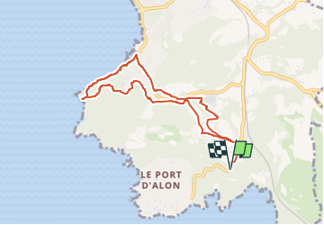
220503 Port d'Alon, dom Bosco, pointe Grenier, La Madrague &R

Rangabe
User

Length
8.8 km

Max alt
91 m

Uphill gradient
230 m
Km-Effort
11.9 km

Min alt
1 m

Downhill gradient
231 m
Boucle
Yes
Creation date :
2022-05-03 06:48:25.673
Updated on :
2022-05-03 15:53:26.016
3h30
Difficulty : Medium

FREE GPS app for hiking
 SityTrail
IGN / Geographical institutes
SityTrail Plus
The world is yours!
About
Trail Walking of 8.8 km to be discovered at Provence-Alpes-Côte d'Azur, Var, Saint-Cyr-sur-Mer. This trail is proposed by Rangabe.
Positioning
Country:
France
Region :
Provence-Alpes-Côte d'Azur
Department/Province :
Var
Municipality :
Saint-Cyr-sur-Mer
Location:
Unknown
Start:(Dec)
Start:(UTM)
720546 ; 4781067 (31T) N.
Comments