


26 DIE Croix de Justin

HAL26
User
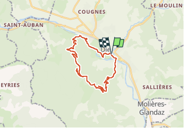

Length
14.7 km

Max alt
986 m

Uphill gradient
634 m
Km-Effort
23 km

Min alt
382 m

Downhill gradient
635 m
Boucle
Yes
Creation date :
2022-05-03 07:06:15.867
Updated on :
2022-05-03 12:11:52.783
3h42
Difficulty : Medium

FREE GPS app for hiking
 SityTrail
IGN / Geographical institutes
SityTrail Plus
The world is yours!
About
Trail Walking of 14.7 km to be discovered at Auvergne-Rhône-Alpes, Drôme, Die. This trail is proposed by HAL26.
Positioning
Country:
France
Region :
Auvergne-Rhône-Alpes
Department/Province :
Drôme
Municipality :
Die
Location:
Unknown
Start:(Dec)
Start:(UTM)
687851 ; 4958047 (31T) N.
Comments