


Frasne le Chateau Cussey

MERMOZ33
User
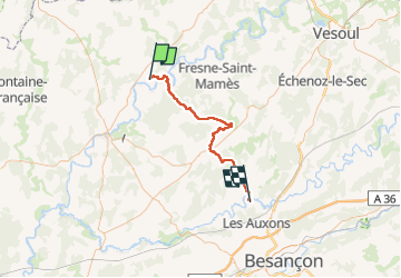

Length
51 km

Max alt
401 m

Uphill gradient
728 m
Km-Effort
61 km

Min alt
187 m

Downhill gradient
686 m
Boucle
No
Creation date :
2022-05-02 05:59:10.09
Updated on :
2022-05-03 13:32:36.421
31h31
Difficulty : Easy

FREE GPS app for hiking
 SityTrail
IGN / Geographical institutes
SityTrail Plus
The world is yours!
About
Trail Walking of 51 km to be discovered at Bourgogne-Franche-Comté, Haute-Saône, Autet. This trail is proposed by MERMOZ33.
Positioning
Country:
France
Region :
Bourgogne-Franche-Comté
Department/Province :
Haute-Saône
Municipality :
Autet
Location:
Unknown
Start:(Dec)
Start:(UTM)
702537 ; 5268881 (31T) N.
Comments