


Les Aiguières

JMJ42
User

Length
12.4 km

Max alt
314 m

Uphill gradient
262 m
Km-Effort
15.9 km

Min alt
126 m

Downhill gradient
262 m
Boucle
Yes
Creation date :
2022-05-03 16:29:54.658
Updated on :
2022-05-03 16:34:02.626
3h37
Difficulty : Difficult

FREE GPS app for hiking
 SityTrail
IGN / Geographical institutes
SityTrail Plus
The world is yours!
About
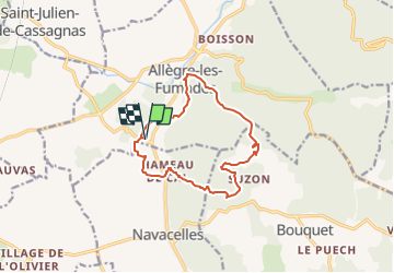
Trail Walking of 12.4 km to be discovered at Occitania, Gard, Allègre-les-Fumades. This trail is proposed by JMJ42.
Description
Très beau points de vue, un peu de DFCI et de goudron mais largement compensés par les Aiguières.
Descente dans le valat de Séguissous un peu difficile.
Positioning
Country:
France
Region :
Occitania
Department/Province :
Gard
Municipality :
Allègre-les-Fumades
Location:
Unknown
Start:(Dec)
Start:(UTM)
598494 ; 4893151 (31T) N.
Comments
La randonnée est plutôt sympa. Un peu difficile avant d'arrivés aux Aiguières puisque que le chemins est escarpé avec des cailloux, mais une fois en bas le spot est très jolie, même si la rivière manquée un peu d'eau.