


Balbigny

taguette
User
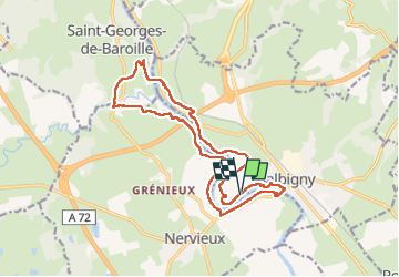

Length
17.1 km

Max alt
377 m

Uphill gradient
183 m
Km-Effort
19.6 km

Min alt
314 m

Downhill gradient
185 m
Boucle
Yes
Creation date :
2022-05-04 06:19:04.078
Updated on :
2022-05-04 10:03:10.014
3h41
Difficulty : Difficult

FREE GPS app for hiking
 SityTrail
IGN / Geographical institutes
SityTrail Plus
The world is yours!
About
Trail Walking of 17.1 km to be discovered at Auvergne-Rhône-Alpes, Loire, Balbigny. This trail is proposed by taguette.
Positioning
Country:
France
Region :
Auvergne-Rhône-Alpes
Department/Province :
Loire
Municipality :
Balbigny
Location:
Unknown
Start:(Dec)
Start:(UTM)
590854 ; 5074196 (31T) N.
Comments