


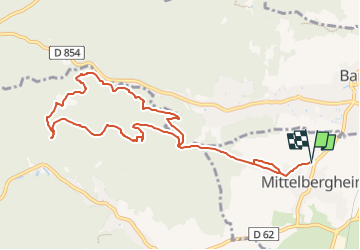
Parking du Zotzenberg à Mittelbergheim-Château d'Andlau-Château de Spesbourg-Hungerplatz-Chapelle St Anne et retour

patrickbeyrath
User

Length
10 km

Max alt
498 m

Uphill gradient
347 m
Km-Effort
14.6 km

Min alt
234 m

Downhill gradient
346 m
Boucle
Yes
Creation date :
2022-05-04 14:13:13.209
Updated on :
2022-05-05 08:26:25.439
4h06
Difficulty : Medium

FREE GPS app for hiking
 SityTrail
IGN / Geographical institutes
SityTrail Plus
The world is yours!
About
Trail Walking of 10 km to be discovered at Grand Est, Bas-Rhin, Mittelbergheim. This trail is proposed by patrickbeyrath.
Positioning
Country:
France
Region :
Grand Est
Department/Province :
Bas-Rhin
Municipality :
Mittelbergheim
Location:
Unknown
Start:(Dec)
Start:(UTM)
384677 ; 5361807 (32U) N.
Comments