


les etrils langon

lecmic
User
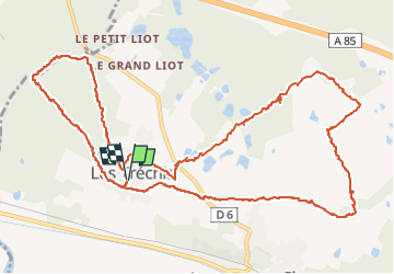

Length
14.3 km

Max alt
136 m

Uphill gradient
88 m
Km-Effort
15.4 km

Min alt
119 m

Downhill gradient
88 m
Boucle
Yes
Creation date :
2022-05-04 11:48:46.657
Updated on :
2022-05-04 14:59:35.177
2h58
Difficulty : Very easy

FREE GPS app for hiking
 SityTrail
IGN / Geographical institutes
SityTrail Plus
The world is yours!
About
Trail Walking of 14.3 km to be discovered at Centre-Loire Valley, Loir-et-Cher, Langon-sur-Cher. This trail is proposed by lecmic.
Description
rando
Positioning
Country:
France
Region :
Centre-Loire Valley
Department/Province :
Loir-et-Cher
Municipality :
Langon-sur-Cher
Location:
Unknown
Start:(Dec)
Start:(UTM)
409819 ; 5238531 (31T) N.
Comments