Trail Walking Domessargues - Domessargues vers Nozières - Photo

Domessargues vers Nozières

© OpenStreetMap contributors
Length
Length
9.8 km
Max alt
Max alt
182 m
Uphill gradient
Uphill gradient
174 m
Km-Effort
Km-Effort  
12.1 km
Min alt
Min alt
86 m
Downhill gradient
Downhill gradient
175 m
Boucle
Boucle
Yes
Creation date :
2022-05-05 12:08:50.093
Updated on :
2022-05-15 14:31:44.36

(0 Reviews)

Walking
Walking
3h37
Difficulty : Difficult

Scan this QR Code to open this trail in the SityTrail application

FREE GPS app for hiking

Logo SityTrail SityTrail

IGN / Geographical institutes

Download SityTrail from the App Store Download SityTrail from Google Play

Logo SityTrail SityTrail World

The world is yours!

Download SityTrail from the App Store Download SityTrail from Google Play Download SityTrail on Huawei AppGallery

About

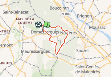
Trail Walking of 9.8 km to be discovered at Occitania, Gard, Domessargues. This trail is proposed by caroline116.

Description

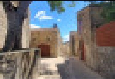
Que des beaux chemins hormis la toute fin avec dernier 500 m sur route très passante

Elevation profile

Positioning

Country:
France
Region :
Occitania
Department/Province :
Gard
Municipality :
Domessargues
Location:
Unknown
Start:(UTM)
593599 ; 4869925 (31T) N.

Trails nearby

Trail Walking Cruviers-Lascours - Cruviers Lascours, le chemin de Bellevue et la vallée de la droude - Photo
Walking
Sedille

Walking

Medium
Cruviers-Lascours, Occitania, Gard, France
5.2 km | 6.5 km-effort
1h 28min
Yes
Trail Walking Domessargues - Boucle dans la garrigue entre Domessargues et Boucoiran - Photo
Walking
ARVIEU

Walking

Easy
(1)
Domessargues, Occitania, Gard, France
11.3 km | 14.8 km-effort
4h 0min
Yes
Trail Walking Boucoiran-et-Nozières - Boucoiran le 14/03/2023 - Photo
Walking
mduveau

Walking

Easy
Boucoiran-et-Nozières, Occitania, Gard, France
13 km | 16.3 km-effort
4h 25min
Yes
Trail Walking Boucoiran-et-Nozières - Boudoir à - Photo
Walking
mduveau

Walking

Easy
Boucoiran-et-Nozières, Occitania, Gard, France
12.6 km | 15.7 km-effort
4h 26min
Yes
Trail Walking Ners - J 4 Pont de Ners  Alès La Regordane - Photo
Walking
jeanneruols

Walking

Difficult
Ners, Occitania, Gard, France
21 km | 25 km-effort
5h 44min
No
Trail Walking Moussac - J 3bis  Moussac Pont de Ners La Regordane - Photo
Walking
jeanneruols

Walking

Medium
Moussac, Occitania, Gard, France
17.2 km | 21 km-effort
4h 42min
No
Trail Walking Brignon - Brignon à Cruviers-Lascours boucle - Photo
Walking
caroline116

Walking

Medium
Brignon, Occitania, Gard, France
9.9 km | 11.2 km-effort
2h 22min
Yes
Trail Walking Saint-Bénézet - 30 mauressargue - Photo
Walking
himba26100

Walking

Very easy
Saint-Bénézet, Occitania, Gard, France
25 km | 30 km-effort
7h 2min
No
Trail Walking Mauressargues - 30 mauressargues - Photo
Walking
himba26100

Walking

Very easy
Mauressargues, Occitania, Gard, France
6.9 km | 8.3 km-effort
1h 38min
Yes


Close
My subscriptions