


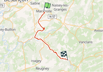
Villafans Mouthier haute pierre

MERMOZ33
User

Length
38 km

Max alt
635 m

Uphill gradient
715 m
Km-Effort
48 km

Min alt
326 m

Downhill gradient
763 m
Boucle
No
Creation date :
2022-05-05 05:20:35.138
Updated on :
2022-05-06 09:07:26.232
27h44
Difficulty : Very easy

FREE GPS app for hiking
 SityTrail
IGN / Geographical institutes
SityTrail Plus
The world is yours!
About
Trail Walking of 38 km to be discovered at Bourgogne-Franche-Comté, Doubs, Mamirolle. This trail is proposed by MERMOZ33.
Positioning
Country:
France
Region :
Bourgogne-Franche-Comté
Department/Province :
Doubs
Municipality :
Mamirolle
Location:
Unknown
Start:(Dec)
Start:(UTM)
284736 ; 5231018 (32T) N.
Comments