


St Just St Rambert cht Grangent

taguette
User
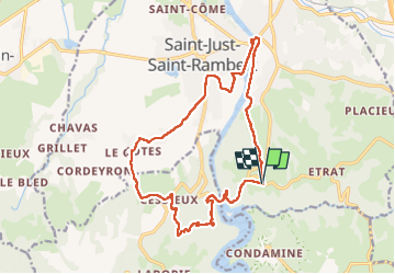

Length
18 km

Max alt
568 m

Uphill gradient
375 m
Km-Effort
23 km

Min alt
363 m

Downhill gradient
377 m
Boucle
Yes
Creation date :
2022-05-06 06:31:07.464
Updated on :
2022-05-06 10:49:03.686
4h15
Difficulty : Very difficult

FREE GPS app for hiking
 SityTrail
IGN / Geographical institutes
SityTrail Plus
The world is yours!
About
Trail Walking of 18 km to be discovered at Auvergne-Rhône-Alpes, Loire, Saint-Just-Saint-Rambert. This trail is proposed by taguette.
Positioning
Country:
France
Region :
Auvergne-Rhône-Alpes
Department/Province :
Loire
Municipality :
Saint-Just-Saint-Rambert
Location:
Saint-Just-sur-Loire
Start:(Dec)
Start:(UTM)
598606 ; 5036037 (31T) N.
Comments