


Pont rean

Yolande Olivier
User
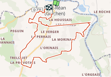

Length
12.5 km

Max alt
100 m

Uphill gradient
230 m
Km-Effort
15.6 km

Min alt
17 m

Downhill gradient
226 m
Boucle
No
Creation date :
2022-05-06 11:54:34.53
Updated on :
2022-05-06 15:13:38.035
3h17
Difficulty : Difficult

FREE GPS app for hiking
 SityTrail
IGN / Geographical institutes
SityTrail Plus
The world is yours!
About
Trail Walking of 12.5 km to be discovered at Brittany, Ille-et-Vilaine, Guichen. This trail is proposed by Yolande Olivier.
Positioning
Country:
France
Region :
Brittany
Department/Province :
Ille-et-Vilaine
Municipality :
Guichen
Location:
Unknown
Start:(Dec)
Start:(UTM)
591243 ; 5316903 (30T) N.
Comments