


RANDO FAITE BREVET 7 MAI

claude nier
User
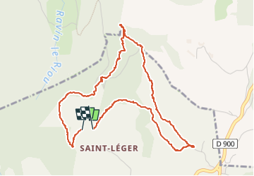

Length
5.5 km

Max alt
1405 m

Uphill gradient
157 m
Km-Effort
7.6 km

Min alt
1310 m

Downhill gradient
154 m
Boucle
Yes
Creation date :
2022-05-07 07:37:39.229
Updated on :
2022-05-07 12:23:34.889
2h45
Difficulty : Medium

FREE GPS app for hiking
 SityTrail
IGN / Geographical institutes
SityTrail Plus
The world is yours!
About
Trail Walking of 5.5 km to be discovered at Provence-Alpes-Côte d'Azur, Alpes-de-Haute-Provence, Montclar. This trail is proposed by claude nier.
Positioning
Country:
France
Region :
Provence-Alpes-Côte d'Azur
Department/Province :
Alpes-de-Haute-Provence
Municipality :
Montclar
Location:
Unknown
Start:(Dec)
Start:(UTM)
287799 ; 4921804 (32T) N.
Comments