Trail Walking Flamanville - Tour du cap de Flamanville - Photo

Tour du cap de Flamanville

 ged94
ged94

User

© OpenStreetMap contributors
Length
Length
11.5 km
Max alt
Max alt
83 m
Uphill gradient
Uphill gradient
230 m
Km-Effort
Km-Effort  
14.6 km
Min alt
Min alt
3 m
Downhill gradient
Downhill gradient
230 m
Boucle
Boucle
Yes
Creation date :
2022-05-07 09:45:12.891
Updated on :
2022-05-07 14:31:31.73

(0 Reviews)

Walking
Walking
4h00
Difficulty : Difficult

Scan this QR Code to open this trail in the SityTrail application

FREE GPS app for hiking

Logo SityTrail SityTrail

IGN / Geographical institutes

Download SityTrail from the App Store Download SityTrail from Google Play

Logo SityTrail SityTrail World

The world is yours!

Download SityTrail from the App Store Download SityTrail from Google Play Download SityTrail on Huawei AppGallery

About

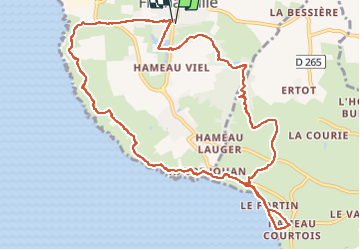
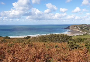
Trail Walking of 11.5 km to be discovered at Normandy, Manche, Flamanville. This trail is proposed by ged94.

Description

Difficile juste à cause d'un passage de 30 m de long un pei vertigineux mais très faisable juste avant d'arriver à la plage de Sciotto.

Elevation profile

Photos

Positioning

Country:
France
Region :
Normandy
Department/Province :
Manche
Municipality :
Flamanville
Location:
Unknown
Start:(UTM)
582018 ; 5486964 (30U) N.

Trails nearby

Trail Walking Les Pieux - Entre terre et mer - Les Pieux - Photo
Walking
tracegps

Walking

Medium
(2)
Les Pieux, Normandy, Manche, France
23 km | 28 km-effort
6h 0min
Yes
Trail Walking Flamanville - Flamanville - Photo
Walking
PatRando

Walking

Medium
Flamanville, Normandy, Manche, France
9.6 km | 12 km-effort
1h 58min
Yes
Trail Mountain bike Flamanville - Rando des Caps 2013 - 65 km - Flamanville - Photo
Mountain bike
tracegps

Mountain bike

Difficult
Flamanville, Normandy, Manche, France
60 km | 73 km-effort
3h 30min
Yes
Trail Mountain bike Flamanville - Rando des Caps 2013 - Flamanville - Photo
Mountain bike
tracegps

Mountain bike

Difficult
Flamanville, Normandy, Manche, France
41 km | 48 km-effort
2h 45min
Yes
Trail Running Les Pieux - Entre terre et mer - Les Pieux - Photo
Running
tracegps

Running

Difficult
Les Pieux, Normandy, Manche, France
23 km | 28 km-effort
3h 0min
Yes
Trail Walking Le Rozel - Le Rozel - Cap de Rozel - Photo
Walking
ged94

Walking

Medium
Le Rozel, Normandy, Manche, France
7.9 km | 9.3 km-effort
2h 47min
Yes
Trail Walking Les Pieux - Les Pieux,  Le Rozel, Flamanville  - Photo
Walking
PascalN

Walking

Medium
Les Pieux, Normandy, Manche, France
21 km | 26 km-effort
4h 5min
Yes
Trail Mountain bike Tréauville - Balade hivernale canton des Pieux - Diélette - Photo
Mountain bike
tracegps

Mountain bike

Medium
Tréauville, Normandy, Manche, France
25 km | 30 km-effort
1h 45min
Yes
Trail Mountain bike Flamanville - Rando des Caps 2012 - 55 km - Flamanville - Photo
Mountain bike
tracegps

Mountain bike

Difficult
Flamanville, Normandy, Manche, France
56 km | 67 km-effort
3h 0min
No


Close
My subscriptions