


avignon

mthomas30
User
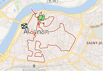

Length
9.7 km

Max alt
58 m

Uphill gradient
103 m
Km-Effort
11.1 km

Min alt
17 m

Downhill gradient
114 m
Boucle
No
Creation date :
2022-05-07 19:14:52.984
Updated on :
2022-05-07 23:22:09.313
1h47
Difficulty : Medium

FREE GPS app for hiking
 SityTrail
IGN / Geographical institutes
SityTrail Plus
The world is yours!
About
Trail Trail of 9.7 km to be discovered at Provence-Alpes-Côte d'Azur, Vaucluse, Avignon. This trail is proposed by mthomas30.
Positioning
Country:
France
Region :
Provence-Alpes-Côte d'Azur
Department/Province :
Vaucluse
Municipality :
Avignon
Location:
Unknown
Start:(Dec)
Start:(UTM)
644946 ; 4868001 (31T) N.
Comments