
table des Géants

apa
User
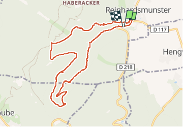

Length
10.4 km

Max alt
615 m

Uphill gradient
324 m
Km-Effort
14.7 km

Min alt
341 m

Downhill gradient
321 m
Boucle
Yes
Creation date :
2022-05-03 07:21:25.067
Updated on :
2022-05-08 07:39:43.01
3h06
Difficulty : Easy

FREE GPS app for hiking
 SityTrail
IGN / Geographical institutes
SityTrail Plus
The world is yours!
About
Trail Walking of 10.4 km to be discovered at Grand Est, Bas-Rhin, Reinhardsmunster. This trail is proposed by apa.
Description
Bucolique le retour
Photos


Positioning
Country:
France
Region :
Grand Est
Department/Province :
Bas-Rhin
Municipality :
Reinhardsmunster
Location:
Unknown
Start:(Dec)
Start:(UTM)
375811 ; 5392435 (32U) N.
Comments