


cheverny

Rolland Jean Pierre
User
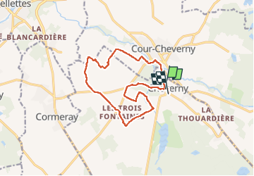

Length
13.3 km

Max alt
111 m

Uphill gradient
96 m
Km-Effort
14.6 km

Min alt
80 m

Downhill gradient
99 m
Boucle
No
Creation date :
2022-05-08 06:22:20.747
Updated on :
2022-05-08 09:38:16.438
3h14
Difficulty : Easy

FREE GPS app for hiking
 SityTrail
IGN / Geographical institutes
SityTrail Plus
The world is yours!
About
Trail Walking of 13.3 km to be discovered at Centre-Loire Valley, Loir-et-Cher, Cheverny. This trail is proposed by Rolland Jean Pierre .
Description
Marche
Positioning
Country:
France
Region :
Centre-Loire Valley
Department/Province :
Loir-et-Cher
Municipality :
Cheverny
Location:
Unknown
Start:(Dec)
Start:(UTM)
384022 ; 5261806 (31T) N.
Comments