


saint Paul en Cornillon

taguette
User
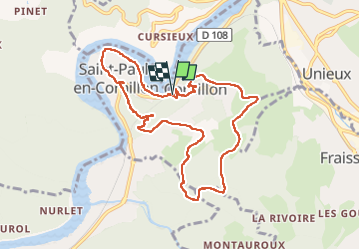

Length
9.6 km

Max alt
710 m

Uphill gradient
423 m
Km-Effort
15.2 km

Min alt
420 m

Downhill gradient
416 m
Boucle
Yes
Creation date :
2022-05-08 08:07:07.228
Updated on :
2022-05-08 10:59:50.949
2h50
Difficulty : Medium

FREE GPS app for hiking
 SityTrail
IGN / Geographical institutes
SityTrail Plus
The world is yours!
About
Trail Walking of 9.6 km to be discovered at Auvergne-Rhône-Alpes, Loire, Saint-Paul-en-Cornillon. This trail is proposed by taguette.
Positioning
Country:
France
Region :
Auvergne-Rhône-Alpes
Department/Province :
Loire
Municipality :
Saint-Paul-en-Cornillon
Location:
Unknown
Start:(Dec)
Start:(UTM)
596712 ; 5027740 (31T) N.
Comments