


WICK-HAUT KOENIGSBOURG-ABRI PAIN D'EPICECHAPELLE DE L'AIGLE-WICK

patrickbeyrath
User
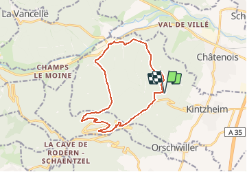

Length
13.6 km

Max alt
706 m

Uphill gradient
542 m
Km-Effort
21 km

Min alt
224 m

Downhill gradient
542 m
Boucle
Yes
Creation date :
2018-10-13 05:53:04.472
Updated on :
2018-10-13 05:53:04.482
4h22
Difficulty : Medium

FREE GPS app for hiking
 SityTrail
IGN / Geographical institutes
SityTrail Plus
The world is yours!
About
Trail Walking of 13.6 km to be discovered at Grand Est, Bas-Rhin, Kintzheim. This trail is proposed by patrickbeyrath.
Positioning
Country:
France
Region :
Grand Est
Department/Province :
Bas-Rhin
Municipality :
Kintzheim
Location:
Unknown
Start:(Dec)
Start:(UTM)
379378 ; 5346508 (32U) N.
Comments