


Randonnée à soing cubry et Charentenay

nicolasdresse
User
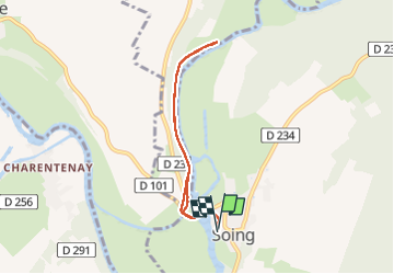

Length
6 km

Max alt
218 m

Uphill gradient
71 m
Km-Effort
7 km

Min alt
195 m

Downhill gradient
71 m
Boucle
Yes
Creation date :
2022-05-08 13:12:09.0
Updated on :
2022-05-08 16:24:13.602
1h11
Difficulty : Medium

FREE GPS app for hiking
 SityTrail
IGN / Geographical institutes
SityTrail Plus
The world is yours!
About
Trail Walking of 6 km to be discovered at Bourgogne-Franche-Comté, Haute-Saône, Soing-Cubry-Charentenay. This trail is proposed by nicolasdresse.
Positioning
Country:
France
Region :
Bourgogne-Franche-Comté
Department/Province :
Haute-Saône
Municipality :
Soing-Cubry-Charentenay
Location:
Unknown
Start:(Dec)
Start:(UTM)
716229 ; 5273904 (31T) N.
Comments