


Montjean

randoposso49
User

Length
9.6 km

Max alt
49 m

Uphill gradient
125 m
Km-Effort
11.3 km

Min alt
6 m

Downhill gradient
125 m
Boucle
Yes
Creation date :
2022-05-08 07:09:59.304
Updated on :
2022-05-09 07:15:54.634
2h44
Difficulty : Medium

FREE GPS app for hiking
 SityTrail
IGN / Geographical institutes
SityTrail Plus
The world is yours!
About
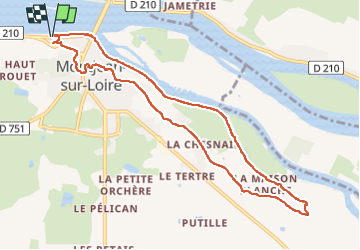
Trail Walking of 9.6 km to be discovered at Pays de la Loire, Maine-et-Loire, Mauges-sur-Loire. This trail is proposed by randoposso49.
Positioning
Country:
France
Region :
Pays de la Loire
Department/Province :
Maine-et-Loire
Municipality :
Mauges-sur-Loire
Location:
Montjean-sur-Loire
Start:(Dec)
Start:(UTM)
660908 ; 5250957 (30T) N.
Comments