


Bas en Basset

taguette
User
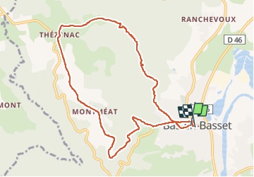

Length
10 km

Max alt
822 m

Uphill gradient
386 m
Km-Effort
15.2 km

Min alt
460 m

Downhill gradient
392 m
Boucle
Yes
Creation date :
2022-05-10 06:26:47.48
Updated on :
2022-05-10 08:53:15.149
2h16
Difficulty : Difficult

FREE GPS app for hiking
 SityTrail
IGN / Geographical institutes
SityTrail Plus
The world is yours!
About
Trail Walking of 10 km to be discovered at Auvergne-Rhône-Alpes, Haute-Loire, Bas-en-Basset. This trail is proposed by taguette.
Positioning
Country:
France
Region :
Auvergne-Rhône-Alpes
Department/Province :
Haute-Loire
Municipality :
Bas-en-Basset
Location:
Unknown
Start:(Dec)
Start:(UTM)
587021 ; 5017500 (31T) N.
Comments