


chamblay

phileasy
User
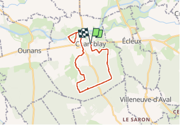

Length
12.9 km

Max alt
270 m

Uphill gradient
115 m
Km-Effort
14.4 km

Min alt
218 m

Downhill gradient
114 m
Boucle
Yes
Creation date :
2022-05-10 07:35:10.81
Updated on :
2022-05-10 11:53:39.646
4h18
Difficulty : Easy

FREE GPS app for hiking
 SityTrail
IGN / Geographical institutes
SityTrail Plus
The world is yours!
About
Trail Walking of 12.9 km to be discovered at Bourgogne-Franche-Comté, Jura, Chamblay. This trail is proposed by phileasy.
Positioning
Country:
France
Region :
Bourgogne-Franche-Comté
Department/Province :
Jura
Municipality :
Chamblay
Location:
Unknown
Start:(Dec)
Start:(UTM)
705968 ; 5208415 (31T) N.
Comments