


blossette.gyre.lyre.Roc.la.tour.l'Ossétie.2022.05.10

trusgnachjf
User
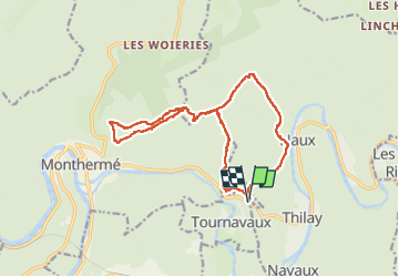

Length
16.2 km

Max alt
425 m

Uphill gradient
589 m
Km-Effort
24 km

Min alt
173 m

Downhill gradient
587 m
Boucle
Yes
Creation date :
2022-05-10 11:42:49.939
Updated on :
2022-05-10 15:56:22.594
4h12
Difficulty : Very difficult

FREE GPS app for hiking
 SityTrail
IGN / Geographical institutes
SityTrail Plus
The world is yours!
About
Trail Walking of 16.2 km to be discovered at Grand Est, Ardennes, Tournavaux. This trail is proposed by trusgnachjf.
Positioning
Country:
France
Region :
Grand Est
Department/Province :
Ardennes
Municipality :
Tournavaux
Location:
Unknown
Start:(Dec)
Start:(UTM)
628697 ; 5526467 (31U) N.
Comments