


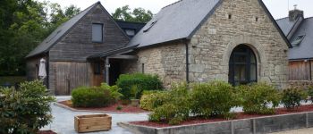
GR341-Penquesten-Quistinic Kerléguennec "La grange à Marie"

AHervé56
User


6h26
Difficulty : Very difficult

FREE GPS app for hiking
 SityTrail
IGN / Geographical institutes
SityTrail Plus
The world is yours!
About
Trail Walking of 21 km to be discovered at Brittany, Morbihan, Inzinzac-Lochrist. This trail is proposed by AHervé56.
Description
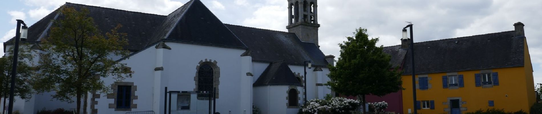
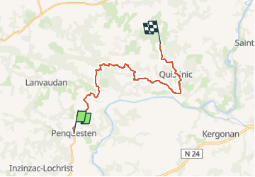
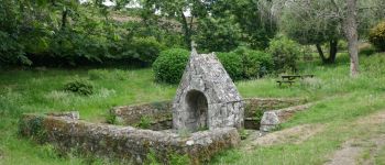
Tronçon du GR341 entre Inzinzac Lochrist et Quistinic.
Départ accessible via bus CTRL 14 et 104
Retour possible le lendemain matin par bus Quistinic Hennebont 134 (correspondance avec le 14 pour Lorient).
Autre option (ma préférence) : laisser sa voiture à Bubry et prendre le 104 jusqu'à Penquesten. Faire le tronçon Quistinic Bubry le lendemain.
A souligner: la qualité de l'accueil, le confort et la convivialité du gite "La grange à marie".
Cartes 0720ET et 0819SB
Photos
 "
data-pinterest-text="Pin it"
data-tweet-text="share on twitter"
data-facebook-share-url="https://www.sitytrail.com/en/trails/3237409-inzinzacxlochrist--gr341xpenquestenxquistinic-kerleguennec-xla-grange-a-mariex/?photo=1#lg=1&slide=1"
data-twitter-share-url="https://www.sitytrail.com/en/trails/3237409-inzinzacxlochrist--gr341xpenquestenxquistinic-kerleguennec-xla-grange-a-mariex/?photo=1#lg=1&slide=1"
data-googleplus-share-url="https://www.sitytrail.com/en/trails/3237409-inzinzacxlochrist--gr341xpenquestenxquistinic-kerleguennec-xla-grange-a-mariex/?photo=1#lg=1&slide=1"
data-pinterest-share-url="https://www.sitytrail.com/en/trails/3237409-inzinzacxlochrist--gr341xpenquestenxquistinic-kerleguennec-xla-grange-a-mariex/?photo=1#lg=1&slide=1">
"
data-pinterest-text="Pin it"
data-tweet-text="share on twitter"
data-facebook-share-url="https://www.sitytrail.com/en/trails/3237409-inzinzacxlochrist--gr341xpenquestenxquistinic-kerleguennec-xla-grange-a-mariex/?photo=1#lg=1&slide=1"
data-twitter-share-url="https://www.sitytrail.com/en/trails/3237409-inzinzacxlochrist--gr341xpenquestenxquistinic-kerleguennec-xla-grange-a-mariex/?photo=1#lg=1&slide=1"
data-googleplus-share-url="https://www.sitytrail.com/en/trails/3237409-inzinzacxlochrist--gr341xpenquestenxquistinic-kerleguennec-xla-grange-a-mariex/?photo=1#lg=1&slide=1"
data-pinterest-share-url="https://www.sitytrail.com/en/trails/3237409-inzinzacxlochrist--gr341xpenquestenxquistinic-kerleguennec-xla-grange-a-mariex/?photo=1#lg=1&slide=1">
 "
data-pinterest-text="Pin it"
data-tweet-text="share on twitter"
data-facebook-share-url="https://www.sitytrail.com/en/trails/3237409-inzinzacxlochrist--gr341xpenquestenxquistinic-kerleguennec-xla-grange-a-mariex/?photo=2#lg=1&slide=2"
data-twitter-share-url="https://www.sitytrail.com/en/trails/3237409-inzinzacxlochrist--gr341xpenquestenxquistinic-kerleguennec-xla-grange-a-mariex/?photo=2#lg=1&slide=2"
data-googleplus-share-url="https://www.sitytrail.com/en/trails/3237409-inzinzacxlochrist--gr341xpenquestenxquistinic-kerleguennec-xla-grange-a-mariex/?photo=2#lg=1&slide=2"
data-pinterest-share-url="https://www.sitytrail.com/en/trails/3237409-inzinzacxlochrist--gr341xpenquestenxquistinic-kerleguennec-xla-grange-a-mariex/?photo=2#lg=1&slide=2">
"
data-pinterest-text="Pin it"
data-tweet-text="share on twitter"
data-facebook-share-url="https://www.sitytrail.com/en/trails/3237409-inzinzacxlochrist--gr341xpenquestenxquistinic-kerleguennec-xla-grange-a-mariex/?photo=2#lg=1&slide=2"
data-twitter-share-url="https://www.sitytrail.com/en/trails/3237409-inzinzacxlochrist--gr341xpenquestenxquistinic-kerleguennec-xla-grange-a-mariex/?photo=2#lg=1&slide=2"
data-googleplus-share-url="https://www.sitytrail.com/en/trails/3237409-inzinzacxlochrist--gr341xpenquestenxquistinic-kerleguennec-xla-grange-a-mariex/?photo=2#lg=1&slide=2"
data-pinterest-share-url="https://www.sitytrail.com/en/trails/3237409-inzinzacxlochrist--gr341xpenquestenxquistinic-kerleguennec-xla-grange-a-mariex/?photo=2#lg=1&slide=2">
 "
data-pinterest-text="Pin it"
data-tweet-text="share on twitter"
data-facebook-share-url="https://www.sitytrail.com/en/trails/3237409-inzinzacxlochrist--gr341xpenquestenxquistinic-kerleguennec-xla-grange-a-mariex/?photo=3#lg=1&slide=3"
data-twitter-share-url="https://www.sitytrail.com/en/trails/3237409-inzinzacxlochrist--gr341xpenquestenxquistinic-kerleguennec-xla-grange-a-mariex/?photo=3#lg=1&slide=3"
data-googleplus-share-url="https://www.sitytrail.com/en/trails/3237409-inzinzacxlochrist--gr341xpenquestenxquistinic-kerleguennec-xla-grange-a-mariex/?photo=3#lg=1&slide=3"
data-pinterest-share-url="https://www.sitytrail.com/en/trails/3237409-inzinzacxlochrist--gr341xpenquestenxquistinic-kerleguennec-xla-grange-a-mariex/?photo=3#lg=1&slide=3">
"
data-pinterest-text="Pin it"
data-tweet-text="share on twitter"
data-facebook-share-url="https://www.sitytrail.com/en/trails/3237409-inzinzacxlochrist--gr341xpenquestenxquistinic-kerleguennec-xla-grange-a-mariex/?photo=3#lg=1&slide=3"
data-twitter-share-url="https://www.sitytrail.com/en/trails/3237409-inzinzacxlochrist--gr341xpenquestenxquistinic-kerleguennec-xla-grange-a-mariex/?photo=3#lg=1&slide=3"
data-googleplus-share-url="https://www.sitytrail.com/en/trails/3237409-inzinzacxlochrist--gr341xpenquestenxquistinic-kerleguennec-xla-grange-a-mariex/?photo=3#lg=1&slide=3"
data-pinterest-share-url="https://www.sitytrail.com/en/trails/3237409-inzinzacxlochrist--gr341xpenquestenxquistinic-kerleguennec-xla-grange-a-mariex/?photo=3#lg=1&slide=3">
 "
data-pinterest-text="Pin it"
data-tweet-text="share on twitter"
data-facebook-share-url="https://www.sitytrail.com/en/trails/3237409-inzinzacxlochrist--gr341xpenquestenxquistinic-kerleguennec-xla-grange-a-mariex/?photo=4#lg=1&slide=4"
data-twitter-share-url="https://www.sitytrail.com/en/trails/3237409-inzinzacxlochrist--gr341xpenquestenxquistinic-kerleguennec-xla-grange-a-mariex/?photo=4#lg=1&slide=4"
data-googleplus-share-url="https://www.sitytrail.com/en/trails/3237409-inzinzacxlochrist--gr341xpenquestenxquistinic-kerleguennec-xla-grange-a-mariex/?photo=4#lg=1&slide=4"
data-pinterest-share-url="https://www.sitytrail.com/en/trails/3237409-inzinzacxlochrist--gr341xpenquestenxquistinic-kerleguennec-xla-grange-a-mariex/?photo=4#lg=1&slide=4">
"
data-pinterest-text="Pin it"
data-tweet-text="share on twitter"
data-facebook-share-url="https://www.sitytrail.com/en/trails/3237409-inzinzacxlochrist--gr341xpenquestenxquistinic-kerleguennec-xla-grange-a-mariex/?photo=4#lg=1&slide=4"
data-twitter-share-url="https://www.sitytrail.com/en/trails/3237409-inzinzacxlochrist--gr341xpenquestenxquistinic-kerleguennec-xla-grange-a-mariex/?photo=4#lg=1&slide=4"
data-googleplus-share-url="https://www.sitytrail.com/en/trails/3237409-inzinzacxlochrist--gr341xpenquestenxquistinic-kerleguennec-xla-grange-a-mariex/?photo=4#lg=1&slide=4"
data-pinterest-share-url="https://www.sitytrail.com/en/trails/3237409-inzinzacxlochrist--gr341xpenquestenxquistinic-kerleguennec-xla-grange-a-mariex/?photo=4#lg=1&slide=4">


Positioning
Comments