


Savigny les Beaune - l'abbaye ste marguerite - arcenant

XavierFaidix
User
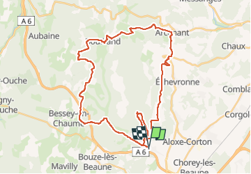

Length
40 km

Max alt
591 m

Uphill gradient
1128 m
Km-Effort
55 km

Min alt
257 m

Downhill gradient
1127 m
Boucle
Yes
Creation date :
2022-05-09 12:11:37.888
Updated on :
2022-05-10 17:37:29.798
2h30
Difficulty : Difficult

FREE GPS app for hiking
 SityTrail
IGN / Geographical institutes
SityTrail Plus
The world is yours!
About
Trail Mountain bike of 40 km to be discovered at Bourgogne-Franche-Comté, Côte-d'Or, Savigny-lès-Beaune. This trail is proposed by XavierFaidix.
Description
VAE
Positioning
Country:
France
Region :
Bourgogne-Franche-Comté
Department/Province :
Côte-d'Or
Municipality :
Savigny-lès-Beaune
Location:
Unknown
Start:(Dec)
Start:(UTM)
638374 ; 5213501 (31T) N.
Comments