


Retournac

taguette
User
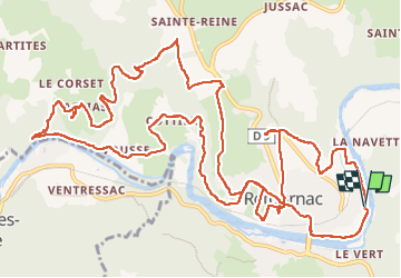

Length
19 km

Max alt
683 m

Uphill gradient
529 m
Km-Effort
26 km

Min alt
494 m

Downhill gradient
525 m
Boucle
Yes
Creation date :
2022-05-11 07:01:31.562
Updated on :
2022-05-11 12:55:40.282
4h36
Difficulty : Very difficult

FREE GPS app for hiking
 SityTrail
IGN / Geographical institutes
SityTrail Plus
The world is yours!
About
Trail Walking of 19 km to be discovered at Auvergne-Rhône-Alpes, Haute-Loire, Retournac. This trail is proposed by taguette.
Positioning
Country:
France
Region :
Auvergne-Rhône-Alpes
Department/Province :
Haute-Loire
Municipality :
Retournac
Location:
Unknown
Start:(Dec)
Start:(UTM)
582098 ; 5006058 (31T) N.
Comments