


mazerolle

groslambert
User
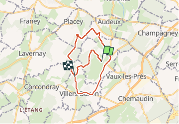

Length
13 km

Max alt
298 m

Uphill gradient
287 m
Km-Effort
16.8 km

Min alt
227 m

Downhill gradient
262 m
Boucle
No
Creation date :
2022-05-11 12:08:31.403
Updated on :
2022-05-11 14:38:40.628
2h28
Difficulty : Easy

FREE GPS app for hiking
 SityTrail
IGN / Geographical institutes
SityTrail Plus
The world is yours!
About
Trail Nordic walking of 13 km to be discovered at Bourgogne-Franche-Comté, Doubs, Mazerolles-le-Salin. This trail is proposed by groslambert.
Positioning
Country:
France
Region :
Bourgogne-Franche-Comté
Department/Province :
Doubs
Municipality :
Mazerolles-le-Salin
Location:
Unknown
Start:(Dec)
Start:(UTM)
716912 ; 5236050 (31T) N.
Comments