


LES GRÈS D'ANNOT

michelpaulin
User
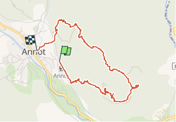

Length
5.7 km

Max alt
1031 m

Uphill gradient
404 m
Km-Effort
11.1 km

Min alt
692 m

Downhill gradient
420 m
Boucle
No
Creation date :
2022-05-12 08:04:46.697
Updated on :
2022-05-13 17:28:26.076
4h01
Difficulty : Medium

FREE GPS app for hiking
 SityTrail
IGN / Geographical institutes
SityTrail Plus
The world is yours!
About
Trail Walking of 5.7 km to be discovered at Provence-Alpes-Côte d'Azur, Alpes-de-Haute-Provence, Annot. This trail is proposed by michelpaulin.
Description
très joli parcours
Photos


Positioning
Country:
France
Region :
Provence-Alpes-Côte d'Azur
Department/Province :
Alpes-de-Haute-Provence
Municipality :
Annot
Location:
Unknown
Start:(Dec)
Start:(UTM)
313242 ; 4870603 (32T) N.
Comments