


Venelles - le bord du canal

mhetpierre
User
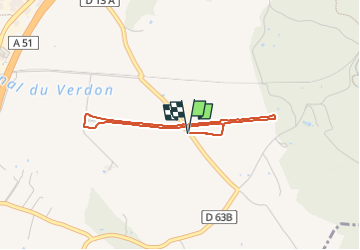

Length
3.4 km

Max alt
344 m

Uphill gradient
26 m
Km-Effort
3.8 km

Min alt
335 m

Downhill gradient
27 m
Boucle
Yes
Creation date :
2022-05-12 15:42:30.0
Updated on :
2022-05-31 22:05:04.256
51m
Difficulty : Easy

FREE GPS app for hiking
 SityTrail
IGN / Geographical institutes
SityTrail Plus
The world is yours!
About
Trail Walking of 3.4 km to be discovered at Provence-Alpes-Côte d'Azur, Bouches-du-Rhône, Venelles. This trail is proposed by mhetpierre.
Positioning
Country:
France
Region :
Provence-Alpes-Côte d'Azur
Department/Province :
Bouches-du-Rhône
Municipality :
Venelles
Location:
Unknown
Start:(Dec)
Start:(UTM)
701291 ; 4828581 (31T) N.
Comments