


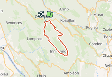
Ordonnaz-Innimond: Mollard de Don

HB01
User

Length
20 km

Max alt
1214 m

Uphill gradient
616 m
Km-Effort
28 km

Min alt
852 m

Downhill gradient
618 m
Boucle
Yes
Creation date :
2022-05-12 08:25:01.245
Updated on :
2022-05-12 17:33:01.54
6h59
Difficulty : Medium

FREE GPS app for hiking
 SityTrail
IGN / Geographical institutes
SityTrail Plus
The world is yours!
About
Trail Walking of 20 km to be discovered at Auvergne-Rhône-Alpes, Ain, Ordonnaz. This trail is proposed by HB01.
Description
Départ Ordonnaz
Positioning
Country:
France
Region :
Auvergne-Rhône-Alpes
Department/Province :
Ain
Municipality :
Ordonnaz
Location:
Unknown
Start:(Dec)
Start:(UTM)
697602 ; 5078268 (31T) N.
Comments