


saint Pierre dû champ

taguette
User
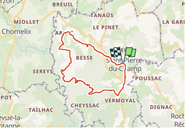

Length
14.8 km

Max alt
961 m

Uphill gradient
375 m
Km-Effort
19.8 km

Min alt
724 m

Downhill gradient
374 m
Boucle
Yes
Creation date :
2022-05-13 06:26:30.264
Updated on :
2022-05-13 09:47:16.244
3h18
Difficulty : Medium

FREE GPS app for hiking
 SityTrail
IGN / Geographical institutes
SityTrail Plus
The world is yours!
About
Trail Walking of 14.8 km to be discovered at Auvergne-Rhône-Alpes, Haute-Loire, Saint-Pierre-du-Champ. This trail is proposed by taguette.
Positioning
Country:
France
Region :
Auvergne-Rhône-Alpes
Department/Province :
Haute-Loire
Municipality :
Saint-Pierre-du-Champ
Location:
Unknown
Start:(Dec)
Start:(UTM)
570585 ; 5010834 (31T) N.
Comments