


Tonquedec

0658294C
User
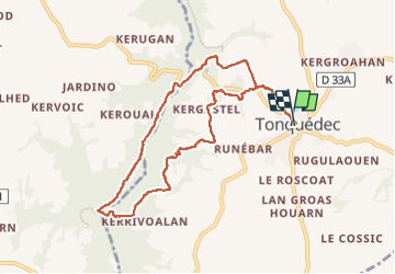

Length
8.7 km

Max alt
91 m

Uphill gradient
113 m
Km-Effort
10.2 km

Min alt
27 m

Downhill gradient
113 m
Boucle
Yes
Creation date :
2022-05-13 12:01:18.0
Updated on :
2022-05-13 15:14:31.9
2h19
Difficulty : Medium

FREE GPS app for hiking
 SityTrail
IGN / Geographical institutes
SityTrail Plus
The world is yours!
About
Trail Walking of 8.7 km to be discovered at Brittany, Côtes-d'Armor, Tonquédec. This trail is proposed by 0658294C.
Positioning
Country:
France
Region :
Brittany
Department/Province :
Côtes-d'Armor
Municipality :
Tonquédec
Location:
Unknown
Start:(Dec)
Start:(UTM)
470752 ; 5390871 (30U) N.
Comments