


Saint-Antonin-Noble-Val

cron
User
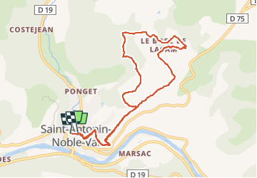

Length
10.1 km

Max alt
336 m

Uphill gradient
306 m
Km-Effort
14.2 km

Min alt
129 m

Downhill gradient
301 m
Boucle
Yes
Creation date :
2022-05-14 07:52:35.649
Updated on :
2022-05-14 11:08:41.448
2h45
Difficulty : Medium

FREE GPS app for hiking
 SityTrail
IGN / Geographical institutes
SityTrail Plus
The world is yours!
About
Trail Walking of 10.1 km to be discovered at Occitania, Tarn-et-Garonne, Saint-Antonin-Noble-Val. This trail is proposed by cron.
Description
Belle petite rando suivant un PR, bien physique au départ. Au retour, on peut suivre la route jusqu'au bourg..
Positioning
Country:
France
Region :
Occitania
Department/Province :
Tarn-et-Garonne
Municipality :
Saint-Antonin-Noble-Val
Location:
Unknown
Start:(Dec)
Start:(UTM)
400399 ; 4889645 (31T) N.
Comments