


Herisson_Sentier_Aumance

jagarnier
User GUIDE
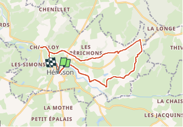

Length
15.1 km

Max alt
303 m

Uphill gradient
257 m
Km-Effort
18.5 km

Min alt
195 m

Downhill gradient
257 m
Boucle
Yes
Creation date :
2022-05-14 11:41:42.959
Updated on :
2022-05-23 11:28:46.632
4h45
Difficulty : Medium

FREE GPS app for hiking
 SityTrail
IGN / Geographical institutes
SityTrail Plus
The world is yours!
About
Trail Walking of 15.1 km to be discovered at Auvergne-Rhône-Alpes, Allier, Hérisson. This trail is proposed by jagarnier.
Positioning
Country:
France
Region :
Auvergne-Rhône-Alpes
Department/Province :
Allier
Municipality :
Hérisson
Location:
Unknown
Start:(Dec)
Start:(UTM)
477865 ; 5150452 (31T) N.
Comments