


trail

oliviergau
User

Length
12.2 km

Max alt
957 m

Uphill gradient
1058 m
Km-Effort
25 km

Min alt
239 m

Downhill gradient
643 m
Boucle
No
Creation date :
2022-05-15 05:21:05.079
Updated on :
2022-05-15 07:34:15.621
2h12
Difficulty : Very easy

FREE GPS app for hiking
 SityTrail
IGN / Geographical institutes
SityTrail Plus
The world is yours!
About
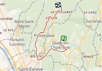
Trail Trail of 12.2 km to be discovered at Auvergne-Rhône-Alpes, Isère, Quaix-en-Chartreuse. This trail is proposed by oliviergau.
Positioning
Country:
France
Region :
Auvergne-Rhône-Alpes
Department/Province :
Isère
Municipality :
Quaix-en-Chartreuse
Location:
Unknown
Start:(Dec)
Start:(UTM)
713233 ; 5014672 (31T) N.
Comments