


digne

mthomas30
User
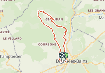

Length
15.5 km

Max alt
1422 m

Uphill gradient
966 m
Km-Effort
29 km

Min alt
593 m

Downhill gradient
1045 m
Boucle
No
Creation date :
2022-05-15 05:34:49.751
Updated on :
2022-05-15 10:22:30.475
4h47
Difficulty : Difficult

FREE GPS app for hiking
 SityTrail
IGN / Geographical institutes
SityTrail Plus
The world is yours!
About
Trail Walking of 15.5 km to be discovered at Provence-Alpes-Côte d'Azur, Alpes-de-Haute-Provence, Digne-les-Bains. This trail is proposed by mthomas30.
Positioning
Country:
France
Region :
Provence-Alpes-Côte d'Azur
Department/Province :
Alpes-de-Haute-Provence
Municipality :
Digne-les-Bains
Location:
Unknown
Start:(Dec)
Start:(UTM)
277683 ; 4885770 (32T) N.
Comments