


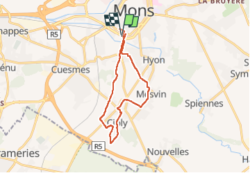
Mons champêtre

laurentgyn
User

Length
12.4 km

Max alt
77 m

Uphill gradient
128 m
Km-Effort
14.1 km

Min alt
30 m

Downhill gradient
128 m
Boucle
Yes
Creation date :
2022-05-15 07:19:50.0
Updated on :
2022-05-15 11:28:20.131
4h07
Difficulty : Easy

FREE GPS app for hiking
 SityTrail
IGN / Geographical institutes
SityTrail Plus
The world is yours!
About
Trail Walking of 12.4 km to be discovered at Wallonia, Hainaut, Mons. This trail is proposed by laurentgyn.
Description
Du centre de Mons , circuit champêtre vers cuesmes , mesvin , ciply, Hyon
La durée , c’est 2h00 pas 4 😇
Positioning
Country:
Belgium
Region :
Wallonia
Department/Province :
Hainaut
Municipality :
Mons
Location:
Unknown
Start:(Dec)
Start:(UTM)
567182 ; 5588720 (31U) N.
Comments