


bjhgfe

Clo0413
User
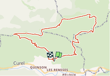

Length
13.1 km

Max alt
1522 m

Uphill gradient
767 m
Km-Effort
23 km

Min alt
838 m

Downhill gradient
766 m
Boucle
Yes
Creation date :
2022-05-15 07:11:20.035
Updated on :
2022-05-15 14:32:05.574
4h08
Difficulty : Very difficult

FREE GPS app for hiking
 SityTrail
IGN / Geographical institutes
SityTrail Plus
The world is yours!
About
Trail Walking of 13.1 km to be discovered at Provence-Alpes-Côte d'Azur, Alpes-de-Haute-Provence, Curel. This trail is proposed by Clo0413.
Positioning
Country:
France
Region :
Provence-Alpes-Côte d'Azur
Department/Province :
Alpes-de-Haute-Provence
Municipality :
Curel
Location:
Unknown
Start:(Dec)
Start:(UTM)
714424 ; 4895206 (31T) N.
Comments