Trail Walking Margegaj - étape 3 : çerem (Al)  Doberdöl (Al) - Photo

étape 3 : çerem (Al) Doberdöl (Al)

 heb
heb

User

© OpenStreetMap contributors
Length
Length
15.5 km
Max alt
Max alt
1930 m
Uphill gradient
Uphill gradient
1108 m
Km-Effort
Km-Effort  
28 km
Min alt
Min alt
1147 m
Downhill gradient
Downhill gradient
468 m
Boucle
Boucle
No
Creation date :
2014-12-10 00:00:00.0
Updated on :
2014-12-10 00:00:00.0

(0 Reviews)

Walking
Walking
6h09
Difficulty : Medium

Scan this QR Code to open this trail in the SityTrail application

FREE GPS app for hiking

Logo SityTrail SityTrail

IGN / Geographical institutes

Download SityTrail from the App Store Download SityTrail from Google Play

Logo SityTrail SityTrail World

The world is yours!

Download SityTrail from the App Store Download SityTrail from Google Play Download SityTrail on Huawei AppGallery

About

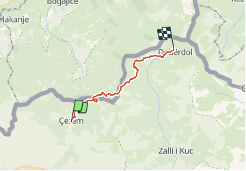
Trail Walking of 15.5 km to be discovered at Northern Albania, Kukës County, Margegaj. This trail is proposed by heb.

Description

Mountain hut in Dobërdol
- d =15.64 km
- dénivelé=1,025 m
- alt.max=1,920 m
- durée=6 hrs

Elevation profile

Positioning

Country:
Albania
Region :
Northern Albania
Department/Province :
Kukës County
Municipality :
Margegaj
Location:
Unknown
Start:(UTM)
414699 ; 4705236 (34T) N.

Trails nearby

Trail Walking Margegaj - étape 2BIS : Valbonë (Al)  çerem (Al) - Photo
Walking
heb

Walking

Difficult
Margegaj, Northern Albania, Kukës County, Albania
21 km | 43 km-effort
8h 39min
No
Trail Walking Margegaj - POB 4 - Cerem to Plav - Photo
Walking
Nicolas Van Meerbeck

Walking

Very easy
Margegaj, Northern Albania, Kukës County, Albania
20 km | 30 km-effort
3h 46min
No


Close
My subscriptions