


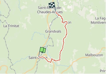
SAINT URCIZE - LA CHALDETTE

gallo
User

Length
17.8 km

Max alt
1179 m

Uphill gradient
336 m
Km-Effort
23 km

Min alt
1004 m

Downhill gradient
437 m
Boucle
No
Creation date :
2022-05-18 13:19:24.786
Updated on :
2022-05-18 13:20:04.651
5h07
Difficulty : Very difficult

FREE GPS app for hiking
 SityTrail
IGN / Geographical institutes
SityTrail Plus
The world is yours!
About
Trail Walking of 17.8 km to be discovered at Auvergne-Rhône-Alpes, Cantal, Saint-Urcize. This trail is proposed by gallo.
Positioning
Country:
France
Region :
Auvergne-Rhône-Alpes
Department/Province :
Cantal
Municipality :
Saint-Urcize
Location:
Unknown
Start:(Dec)
Start:(UTM)
500381 ; 4949404 (31T) N.
Comments