


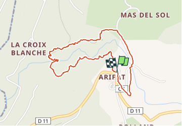
Boucle cascades Arifat

dan69390
User

Length
2.3 km

Max alt
439 m

Uphill gradient
121 m
Km-Effort
3.9 km

Min alt
312 m

Downhill gradient
116 m
Boucle
Yes
Creation date :
2022-05-18 12:46:43.0
Updated on :
2022-05-18 13:56:46.972
1h09
Difficulty : Medium

FREE GPS app for hiking
 SityTrail
IGN / Geographical institutes
SityTrail Plus
The world is yours!
About
Trail Walking of 2.3 km to be discovered at Occitania, Tarn, Arifat. This trail is proposed by dan69390.
Positioning
Country:
France
Region :
Occitania
Department/Province :
Tarn
Municipality :
Arifat
Location:
Unknown
Start:(Dec)
Start:(UTM)
446066 ; 4846852 (31T) N.
Comments
bonjour est-ce qu'on pourrait avoir l'adresse GPX sur l'application car je me sers beaucoup de ma montre qui acceptent les traces GpX