ITI0062-R

jeanic63
User
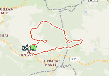

Length
9 km

Max alt
858 m

Uphill gradient
289 m
Km-Effort
12.9 km

Min alt
603 m

Downhill gradient
287 m
Boucle
Yes
Creation date :
2022-05-18 15:12:17.594
Updated on :
2022-05-18 15:19:13.625
2h55
Difficulty : Easy

FREE GPS app for hiking
 SityTrail
IGN / Geographical institutes
SityTrail Plus
The world is yours!
About
Trail On foot of 9 km to be discovered at Auvergne-Rhône-Alpes, Puy-de-Dôme, Aydat. This trail is proposed by jeanic63.
Description
départ église de Ponteix
Positioning
Country:
France
Region :
Auvergne-Rhône-Alpes
Department/Province :
Puy-de-Dôme
Municipality :
Aydat
Location:
Unknown
Start:(Dec)
Start:(UTM)
501928 ; 5056581 (31T) N.
Comments