


Les Salles

taguette
User
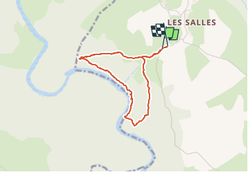

Length
3.2 km

Max alt
916 m

Uphill gradient
176 m
Km-Effort
5.5 km

Min alt
739 m

Downhill gradient
173 m
Boucle
Yes
Creation date :
2022-05-18 14:26:11.16
Updated on :
2022-05-18 15:27:49.572
59m
Difficulty : Easy

FREE GPS app for hiking
 SityTrail
IGN / Geographical institutes
SityTrail Plus
The world is yours!
About
Trail Walking of 3.2 km to be discovered at Auvergne-Rhône-Alpes, Haute-Loire, Saint-Martin-de-Fugères. This trail is proposed by taguette.
Positioning
Country:
France
Region :
Auvergne-Rhône-Alpes
Department/Province :
Haute-Loire
Municipality :
Saint-Martin-de-Fugères
Location:
Unknown
Start:(Dec)
Start:(UTM)
572706 ; 4974898 (31T) N.
Comments