


Colombieres

jpbrion
User
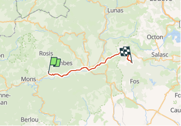

Length
26 km

Max alt
447 m

Uphill gradient
481 m
Km-Effort
32 km

Min alt
168 m

Downhill gradient
377 m
Boucle
No
Creation date :
2022-05-18 12:17:53.0
Updated on :
2022-05-18 15:49:30.652
42m
Difficulty : Easy

FREE GPS app for hiking
 SityTrail
IGN / Geographical institutes
SityTrail Plus
The world is yours!
About
Trail Car of 26 km to be discovered at Occitania, Hérault, Colombières-sur-Orb. This trail is proposed by jpbrion.
Positioning
Country:
France
Region :
Occitania
Department/Province :
Hérault
Municipality :
Colombières-sur-Orb
Location:
Unknown
Start:(Dec)
Start:(UTM)
500915 ; 4825484 (31T) N.
Comments